In April 2017, I set off in my small RV, a 1999 Roadtrek 190 Popular, on an epic photo road trip from Maine to Alaska. I had dreamed about going full time on the road for quite a while, and in the summer of 2016 I finally set things in motion. I bought the old RV and started to get rid of things I didn’t need. By the time I left, I had downsized my life as much as possible, leaving a few things behind to figure out later, but I took everything I needed with me to live and work out of my RV.
I wasn’t really sure where I would end up; I was leaving all options open. Maybe I would fall in love with Alaska and move there. Or, perhaps more likely, the old RV would break down so badly that it wouldn’t be worth fixing it and I’d have to figure out what to do next. But I did know a few things for sure: I wanted to spend the summer in Alaska, and I had a few spots in mind in the U.S. and Canada that I wanted to see first. This was primarily a photography trip, so my destinations all revolved around places I wanted to photograph.
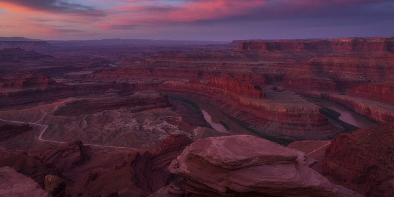
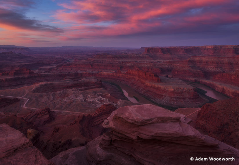
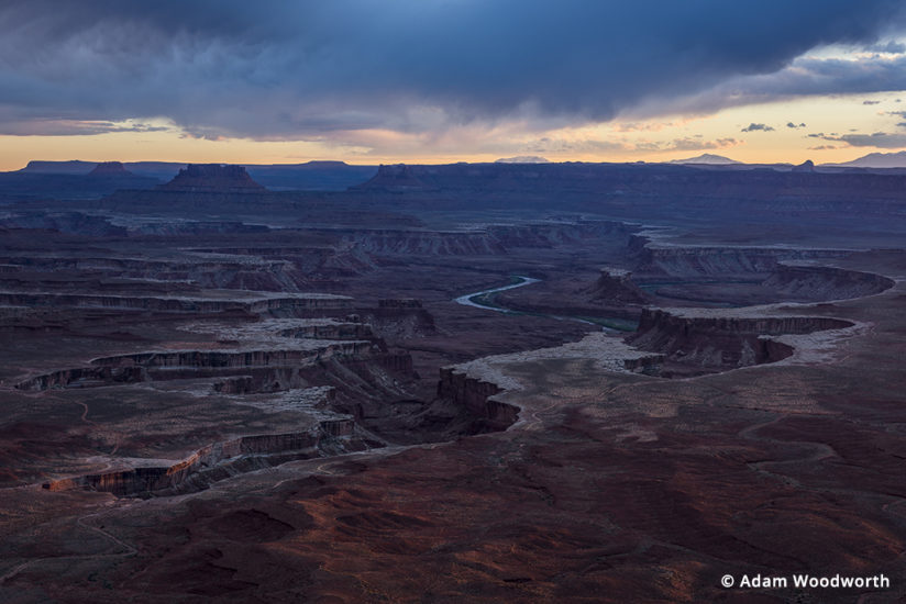
There’s a lot to see between Maine and Alaska, so it’s kind of mind-boggling trying to pick out a route that involves lots of other photo stops on the way. But I knew I wanted to spend most of my time out west photographing the desert and mountains before heading north to Alaska. In general, I wanted to avoid the really crowded and heavily photographed spots, but at the same time there were a few popular places that I was dying to visit, such as Dead Horse Point and Canyonlands in Utah. I love the outdoors, and I’m happy our national parks are popular, but unfortunately in some cases they are overcrowded, and that just isn’t fun.
Some stops were easy to pick. I definitely wanted to see the Rocky Mountains in Colorado and the desert in Utah. From there I figured I would wander my way up to Canada to visit Banff, Lake Louise and Jasper, then head to Alaska. Over time, I learned of a few more spots I wanted to hit, including Great Sand Dunes in Colorado, Goblin Valley in Utah, the Sawtooth Mountains in Idaho and the Kenai Peninsula and Dalton Highway in Alaska. I also knew my first major stop would be in Bardstown, Kentucky, not for photography but for a little bourbon history and tasting! It was on the way, so why not, right?
As exciting as it is seeing iconic locations for the first time, it can be a challenge to think of an interesting way to shoot a spot that hasn’t been done a billion times before. I wouldn’t say I did anything special at many of the iconic spots I hit, and in some cases, like Dead Horse Point or Lake Louise, I took pretty much the same shot everyone takes. But I didn’t let that bother me; there may be a billion photos of the same angle, but I didn’t have my own version of it that captured my experience being there. For example, while at Grand View Point in Canyonlands, I just zoomed in for a composition that isn’t anything new, but the lighting I had that evening with the clouds and just a hint of warm light hitting the rim of the closest canyon was spectacular and captures the moment that I had, standing there in awe of the beauty in front of me.
Despite the beauty of the popular spots and my enjoyment with my photos from them, my favorite thing is being some place less known and less crowded. This requires a lot more research and often lots of driving, but the reward is often enjoying a beautiful spot all to yourself, or at least with far fewer people. Cruising Google Maps and Google Images can be a pretty effective way of finding spots that you haven’t heard of before. See a lake near some mountains that you don’t know anything about? It could have a great reflection shot!
Another great way to find good spots is just to Google “where to photograph in Alaska,” or something to that effect. You’ll see lots of results with places you know, but there will usually be some results that cover other spots you may have not seen before or that at least lead you to the websites of photographers with photos from that area.
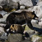
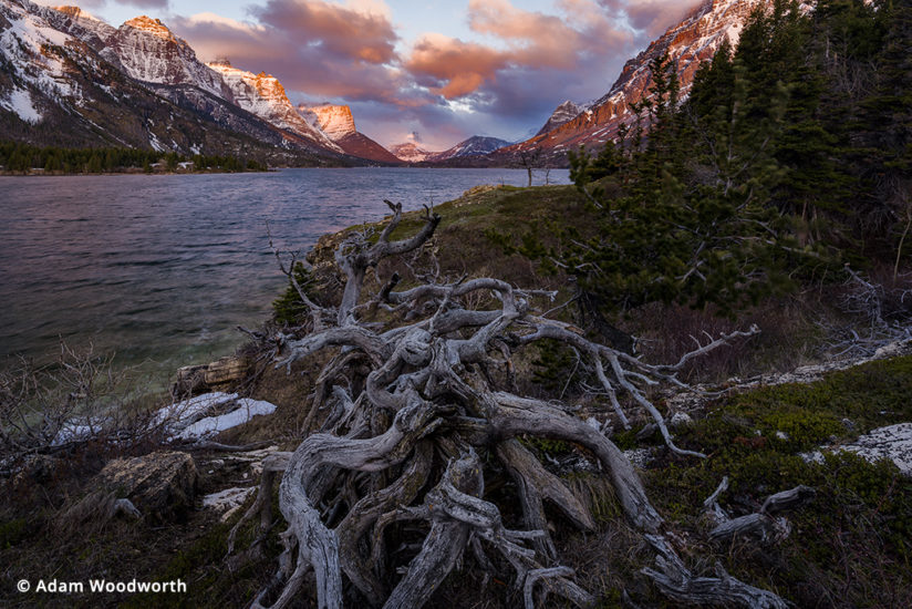
On an open-ended trip like this, I had the luxury of picking my next stops as I went. More often than not, I didn’t know where exactly I would end up next. I had my basic plan, but I was able to branch out from there. While looking at the map sitting in my RV in Idaho, I decided that I might as well visit Glacier National Park before I headed to Alberta, Canada. I arrived at Glacier in early May, and the park was quiet and most of the roads were still closed due to snow. You could only drive a short way in from either side of the park. The snowfall that winter was heavy, and the mountains were still covered. I’ll admit, this was my first time in grizzly bear territory, and I was hesitant to go hiking alone, even with a can of bear spray. So I photographed from the shores of St. Mary Lake and Swiftcurrent Lake. I walked around the shore of St. Mary Lake and found some interesting foreground elements that I personally hadn’t seen in images from this area.
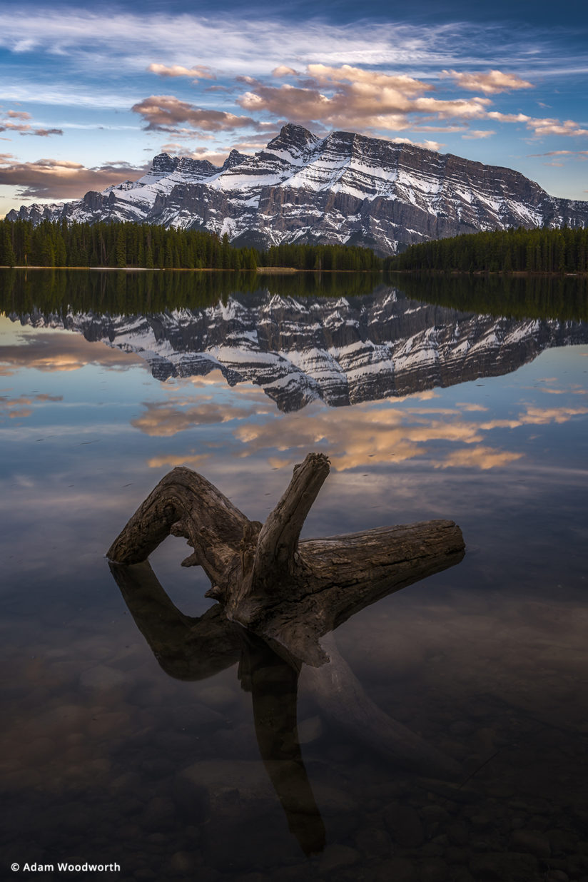
Next it was off to Canada, with Lake Louise and Banff my first stops, then a couple days touring the Icefields Parkway on my way to Jasper. These are all amazing places, but I was limited a little in access again due to some road closures because of snow, and some lakes were still frozen over, so the beautiful turquoise-colored lakes the Canadian Rockies are known for weren’t always visible. But I found some great spots at Sunwapta Falls and Two Jack Lake.
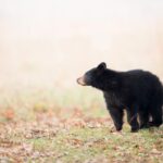
After a couple weeks, it was off to hit the Alaska Highway, a 1,390-mile, two-lane road that starts in Dawson Creek, B.C., and ends in Delta Junction, Alaska. The drive goes through some incredibly beautiful and much more remote areas of the Canadian Rockies, but most of the drive is through the hills and woods of B.C. and the Yukon. When I drove through in late May, there were countless black bears grazing on the grasses along the sides of the road, and on the way back in July, the bears were replaced with stone sheep in the mountains and wood bison in the Yukon.
I didn’t spend too much time photographing on this part of the journey; I was excited to get to Alaska, and this was also the start of my RV problems. One by one, the brakes on my RV started failing on my trip up the Alaska highway and around Alaska itself. Between that and another breakdown, my girlfriend (who joined me for three weeks in Alaska) and I spent four nights in mechanic parking lots awaiting repairs. And while I was still alone, the RV broke down in middle-of-nowhere Alaska. Thank goodness I had a Garmin inReach Explorer+ that has satellite texting, so I could text my girlfriend to call a tow truck.
If you’re going out on a road trip like this, definitely get some sort of satellite communication device. A SPOT Gen3 is nice for push-button “I’m OK” status updates, or “I need emergency assistance” SOS messages, but an inReach or similar device will let you type out text messages and doubles as a single push-button SOS device and GPS. A satellite phone is nice as well, but they are usually much more costly.
Alaska is often considered the final frontier of the U.S. With huge swaths of unpopulated areas and long mountain chains, the area offers endless possibilities for photography. But getting out to those remote areas can be costly if you have to charter a plane. Given the expenses of my RV troubles, I stuck to places I could drive or hike to. Fortunately, Alaska isn’t short on scenery from a hiking trail or roadside spot.
If you’re sticking to the interior roads, then there are only a few spots on the coast you can drive to, but they are all stunning. They can be very crowded in the summer, but the scenery is worth the hassle, at least for a day. Driving through the Kenai Peninsula takes you through stunning mountain views on your way to the oceanside towns of Homer and Seward. If you’re there in the summer, keep your eyes open for scenic spots with lupines and fireweed.
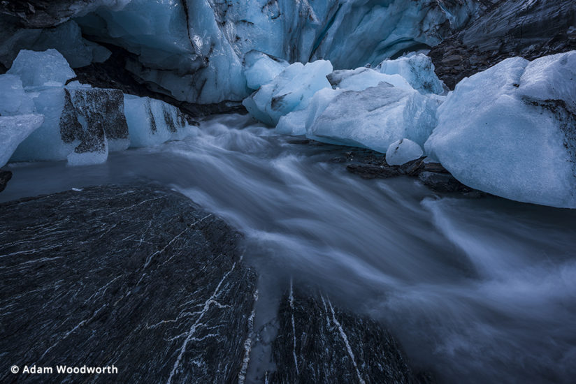
There are more than a few easily accessible glaciers in Alaska. If you’re looking for a quick adventure, I found Worthington Glacier to be an incredible spot. A short hike from the trailhead leads you to the toe of the glacier, and when I was there, the outwash from meltwater was raging pretty good, with waterfalls over some adjacent cliffs and a beautiful stream through huge chunks of ice. For a real glacier expedition, including ice climbing, consider a guided tour of Exit Glacier.
Denali National Park gets all the attention in Alaska, but don’t overlook the many state parks there. Mountains and rivers are everywhere, and the views are stunning. The Eagle River Nature Center near Anchorage, for example, offers views of mountains over a pond from an easy walk to a viewing platform.
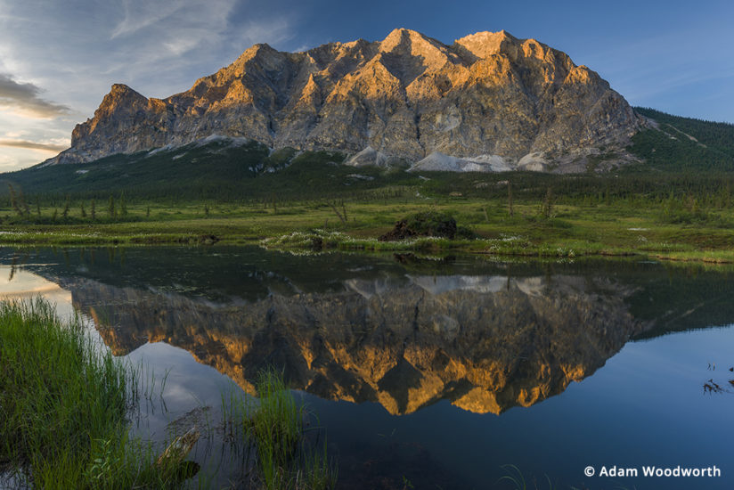
Alaska is also home to some incredibly long dirt roads. These roads are less traveled and a welcome break from the busy areas of Denali, Homer, Seward, etc. The Dalton Highway is the pinnacle of these, a 414-mile road that is 75 percent dirt and gravel. It’s mainly a haul road for transporting equipment and supplies to the oil fields of the Northern Slope, but it takes you through the Arctic Circle and the breathtaking Brooks Range Mountains and the Gates of the Arctic National Park. If you take it all the way to Dead Horse, you can pay for a shuttle bus out to Prudhoe Bay to dip your feet in the Arctic Ocean.
Tips For Your Photo Road Trip
Here are some tips for making the most of your road trip, wherever you go. Remember that the best light on the landscape will usually be around sunrise, sunset or twilight, so save yourself the trouble of heavy crowds in the middle of the day and use that time for things like researching and planning. Arrive at your desired photography spot at least 30 minutes before you expect the light to be good, so you can scout out the location and find a good composition. For really popular spots, you may need to arrive an hour or two early just to get a spot, or just skip them for the less-popular spots.
Take your time when you’re on the road. It’s very easy to get caught up in trying to see a ton of spots as fast as possible. If there’s a good chance you may never be back to that area or won’t be back for a long time, try to relax and enjoy it with your eyes and ears just as much as with your camera. Aim for a few exceptional photos instead of a bunch of mediocre photos.
Wherever you go and however you get there, use a healthy dose of advance planning mixed with spur-of-the-moment adventures. Bring your best camera gear so you don’t regret that shot of the moose you couldn’t get because you left your big zoom lens at home. And, above all, enjoy yourself!
As for my trip, after all that time on the road and seeing all those inspiring places, my heart still felt like it belonged on the coast of Maine, so I headed back in July. I love the road, though, and I’m regularly out on road trips of varying lengths from a few days to a few weeks. Maybe I’ll see you out there.
YOU MIGHT ALSO LIKE
Take The Scenic Route
Make the most of photo opportunities on your next road trip. Read now.
The post Epic Photo Road Trip appeared first on Outdoor Photographer.